Draw a Radius Circle on Any Map Location
This free online radius map tool lets you search for any address or postcode, then draw a circle of a specified distance around it. Whether you need a 5-mile delivery radius, a 10-km catchment area, or a 500-metre noise zone, just enter the value, select the unit, and click the map.
The circle updates live when you change the radius value or unit. Drag the centre marker to reposition without redrawing. The stats bar shows every measurement simultaneously — no unit conversion needed.
Business and Professional Use Cases
Key Features
- Address & Postcode Search — find any location worldwide
- GPS Location — one click to zoom to your current position
- 5 Radius Units — miles, kilometres, metres, feet, yards
- Live Radius Update — change value or unit and the circle resizes instantly
- Draggable Marker — drag the centre point without re-entering draw mode
- Move Mode — click a new map point to relocate the circle centre
- Colour Picker — customise the circle colour
- Full Stats Bar — centre coordinates, radius in all 5 units, area in 7 units
- GeoJSON Export — download the circle boundary as a 128-point geodesic polygon for GIS use
- Basemap Switcher — Street, Satellite, and Terrain base layers
- Fullscreen Mode — expand for a larger working view
How to Use — Step by Step
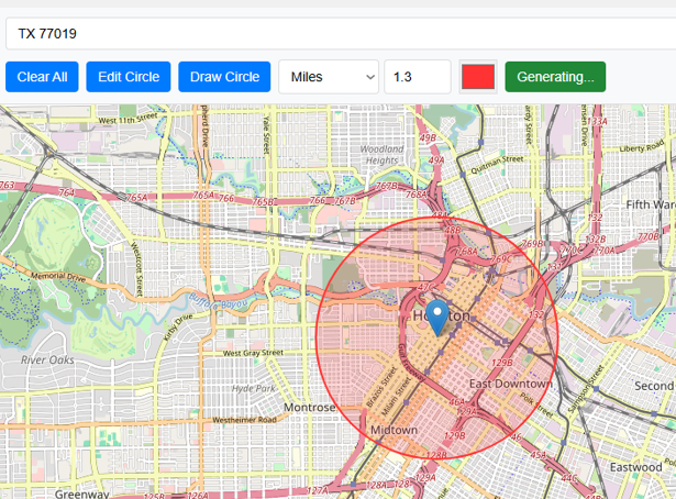
Type any address, place name, or landmark into the search box at the top and click Search. The map zooms to that location automatically.

The map pans and zooms to the searched address, centring the view so you can see the surrounding area clearly before drawing.

You can also search by postal code or ZIP code. The map zooms to the corresponding area — useful for quickly locating a neighbourhood or district.

Choose the unit for your circle radius from the dropdown: Miles, Kilometres, Metres, Feet, or Yards. The unit applies immediately to any existing circle.

Type a radius value in the number box, or click the up/down arrows to adjust in 0.1 steps. For example, enter 5 and select Kilometres to draw a 5 km circle.

Click the green "Draw Circle" button. It turns red and the cursor changes to a crosshair, indicating that draw mode is active and the next map click will place the circle.

Click anywhere on the map to place the circle centre. The circle appears instantly. The stats bar shows the centre coordinates, radius in all units, and area in acres, ha, km², m², ft², yd², and mi².

Click the colour swatch in the toolbar to open the colour picker. Select any colour — the circle updates immediately. Useful when comparing multiple screenshots of different scenarios.

Click "Move Circle" to enter edit mode. The button turns red. The cursor changes to a crosshair. Click a new location on the map to move the circle centre there.

After clicking, the circle redraws at the new centre with the same radius. The stats bar updates with the new coordinates. You can also drag the centre marker directly on the map at any time.

Click "GeoJSON" to download the circle boundary as a standard GeoJSON polygon file (128-point geodesic approximation). Open it in QGIS, ArcGIS, Mapbox, or geojson.io. In QGIS, set the project CRS to EPSG:3857 (Web Mercator) to see the circle as perfectly round.
Click the red "Clear" button to remove the circle from the map and reset all measurements. The map returns to its default view, ready for a new circle.

Radius and Area Unit Reference
| Radius Unit | In Metres |
|---|---|
| 1 Mile | 1,609.344 m |
| 1 Kilometre | 1,000 m |
| 1 Metre | 1 m |
| 1 Foot | 0.3048 m |
| 1 Yard | 0.9144 m |
| Area Unit | Conversion from m² |
|---|---|
| Acres | ÷ 4,046.86 |
| Hectares | ÷ 10,000 |
| km² | ÷ 1,000,000 |
| ft² | × 10.7639 |
| yd² | × 1.19599 |
| mi² | ÷ 2,589,988 |
Frequently Asked Questions
Open Source & Credits
- Map library: Leaflet — open-source interactive maps
- Geocoding: Nominatim / OpenStreetMap — address search
- Map tiles: CARTO Light, OpenStreetMap, Esri (satellite/terrain)